Assigning a CRS changes metadata; interpreting coordinates changes where the data is placed.
Understand EditPolygon's CRS model
EditPolygon separates the CRS in which source coordinates were expressed from the canonical coordinates used by the map and from the CRS you want in a downloaded output.
The coordinate reference system associated with the imported dataset, for example WGS 84 or an MGA zone.
Editable project geometry is normalised to the browser map's canonical geographic storage so layers from different sources can be displayed and edited together.
The CRS selected for a CRS-aware download when the receiving workflow needs projected coordinates.
A suitable projected or geodesic working CRS chosen for algorithms that require real-world distance or robust topology. It does not permanently change project storage.
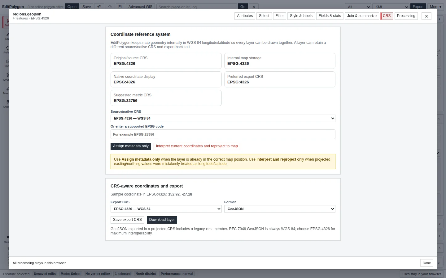
Open the CRS tab
Open the Data/GIS window for an editable layer and choose CRS. Review the layer's source/native CRS, internal map storage, recommended metric CRS and export CRS information before changing anything.
EditPolygon can derive CRS information from supported metadata such as GML srsName, Shapefile .prj, GeoPackage metadata, legacy GeoJSON CRS metadata and ArcGIS service spatial-reference metadata where available.
Assign CRS metadata without moving geometry
Use Assign CRS when the coordinates are already in the correct map position and the missing or incorrect problem is the layer's metadata. Assignment says “these source coordinates belong to this CRS”; it does not reinterpret the currently mapped shape.
If a Brisbane polygon is already drawn over Brisbane and you merely need to record that the source was EPSG:4326, assignment is the appropriate kind of change.
Interpret projected coordinates and reproject them
Use the coordinate interpretation/reprojection action when a projected source was read as though its numbers were longitude/latitude—for example, an easting around 500,000 and northing around 7,000,000 that therefore cannot appear correctly on a longitude/latitude map.
- Identify the actual source CRS.
Use provider metadata, a
.prj, GeoPackage metadata or authoritative knowledge of the dataset. - Select that CRS in the interpretation control.
- Confirm the reinterpretation.
EditPolygon transforms those native coordinates into canonical map storage.
- Check the result against known geography.
A mathematically valid transform can still be the wrong zone or datum.
Several projected systems can place data plausibly near the same region while still introducing material positional error.
MGA, GDA94 and GDA2020
EditPolygon includes common Australian projected CRS support, including MGA zones used with GDA94/GDA2020. UTM/MGA transformations are performed locally in the browser.
Where a transformation between GDA94 and GDA2020 would require an authoritative grid for survey-grade accuracy, EditPolygon's general datum handling should not be treated as a cadastral/survey transformation service. Use the authoritative grid-based workflow required by your organisation for high-precision cadastral work.
View and edit coordinates in another CRS without changing the map
The basemap and interactive map remain Web Mercator (EPSG:3857). All editable feature geometry is stored as WGS 84 longitude/latitude (EPSG:4326), regardless of the coordinates you choose to display or type.
- Enter coordinates in your source CRS.
Choose Add by coordinates and select a supported CRS, such as GDA2020 / MGA Zone 56 (EPSG:7856). Projected coordinates use easting, northing in metres; geographic coordinates can use latitude/longitude or longitude/latitude. A preview checks numerical ranges before creating geometry. The input is transformed to WGS 84 for internal storage.
- Choose a layer's coordinate-display CRS.
In Advanced GIS, open the layer's CRS tab and choose View and edit coordinates in. The Inspector displays the first coordinate in that CRS. This preference is separate from the original source CRS and preferred export CRS.
- Edit the selected feature's coordinates.
Select a feature in the map, then open its layer's CRS tab. The JSON geometry editor shows projected coordinates when a projected CRS is selected. Review and apply changes explicitly. The editor checks coordinate ranges, feature type and polygon-ring closure, and refuses to overwrite geometry changed since the editing session opened. Undo is available.
Projected-coordinate editing does not alter the basemap or change stored geometries into an alternate map projection. Canonical true circles retain their specialist centre/radius controls; use an exported polygon approximation if you need direct polygon-coordinate editing.
Processing chooses a metric working CRS when required
Algorithms such as Simplify, Densify, Snap and several GEOS overlay operations need meaningful metric/topological calculations. Processing can project the scoped request into a suitable local metric CRS, run the one shared operation, and transform the result back to canonical project storage.
For tools that operate in a projected metric space, Advanced GIS now offers an Automatic working CRS or a supported projected metre-based system. For Australian state-scale inputs, Automatic can use GDA94 / Australian Albers (EPSG:3577) instead of treating Web Mercator as an accurate area projection. Geodesic tools such as standard Buffer retain their geodesic behaviour. The Processing result/preview reports the working CRS where relevant. You normally do not need to permanently reproject the project layer merely because a Processing algorithm uses metres.
Planar calculations and accuracy
For a selected line or polygon, the CRS tab can show length/perimeter and area calculated in a supported projected metric CRS. Use an appropriate local MGA/UTM zone for regional measurements; Australian Albers is an equal-area option for broader Australian datasets. The existing map measurements remain geodesic and independent of your coordinate-display preference. Web Mercator is not offered as a precision metric working CRS.
Export a layer in another CRS
The main Export dialog and file Converter now offer output CRS choices for GeoJSON, Shapefile ZIP, WKT and CSV; the layer's CRS tab also offers CRS-aware downloads. Choose an appropriate destination CRS and confirm the transformed coordinates in the receiving system. KML/KMZ, the ordinary GML interchange path and TopoJSON remain WGS 84 in the main export workflow, rather than silently writing incompatible coordinates. The CRS tab allows you to set an export CRS and download supported formats using coordinates transformed for the destination. Choose the format offered by the current CRS export controls and verify the result in the receiving GIS.
Shapefile exports should carry matching projection metadata. For text formats such as WKT/CSV, make sure the receiving workflow knows what CRS the coordinate numbers represent.
Retain optional fields in a CRS-aware export
The CRS tab's Download layer action uses Geometry only by default, with Preserve compatible data for selected attributes, IDs and other supported categories. These choices are independent of the selected target CRS; they do not recover metadata lost by the importer or reverse any earlier geometry generalisation.
Projected GeoJSON includes a legacy crs member; ordinary standards-oriented GeoJSON uses WGS 84 / EPSG:4326. CRS-aware Shapefile ZIP can include a generated PRJ and UTF-8 CPG, subject to DBF field-name and type limits. See Export data and save projects for the full compatibility matrix.
Troubleshoot a misplaced layer
The file imported but nothing appears near the expected area
Use Fit first, then inspect coordinate ranges and CRS metadata. Large projected eastings/northings interpreted as longitude/latitude need coordinate interpretation, not geometry repair.
The layer is close but not exactly aligned with authoritative data
Check datum, zone and transformation accuracy. A general transformation may be unsuitable for survey-grade alignment.
Processing reports a projected CRS even though my layer says EPSG:4326
That is expected for metric/topology work. The Processing CRS is temporary working space; project storage remains canonical.
Assigning a CRS moved nothing
That is the point of assignment. If the raw coordinate numbers themselves need to be interpreted in another CRS, use the interpretation/reprojection workflow instead.
- You know whether the problem is missing metadata or incorrectly interpreted coordinates.
- The source CRS comes from reliable metadata or authoritative knowledge rather than visual guessing.
- Projected data was checked against known geography after interpretation.
- Processing working CRS is not being confused with permanent project storage.
- The export CRS matches the receiving system's requirements.
- Survey-grade datum transformation is handled in an authoritative workflow when required.