Choose the spatial relationship first; then decide whether you need selection, copied attributes or aggregated statistics.
Start by defining the spatial question
A spatial join is not simply “which polygons are near each other?” Choose the relationship that describes the data question first, then choose whether you need a selection, copied attributes or an aggregate statistic.
The two geometries share any point or area. Use this when large zones cross many smaller administrative polygons.
The complete input geometry lies inside the comparison geometry. A large district crossing several LGAs is not Within any one of those LGAs.
The input geometry contains the comparison geometry.
Use the more specific topological relationship when sharing only a boundary, partial same-dimension overlap, or no intersection is the actual question.
If the question is “which LGAs have any area in each Fire Weather District?”, use Intersects. Using Within asks whether an entire Fire Weather District is contained in a single LGA and will miss the crossings you can plainly see on the map.
Join attributes by location
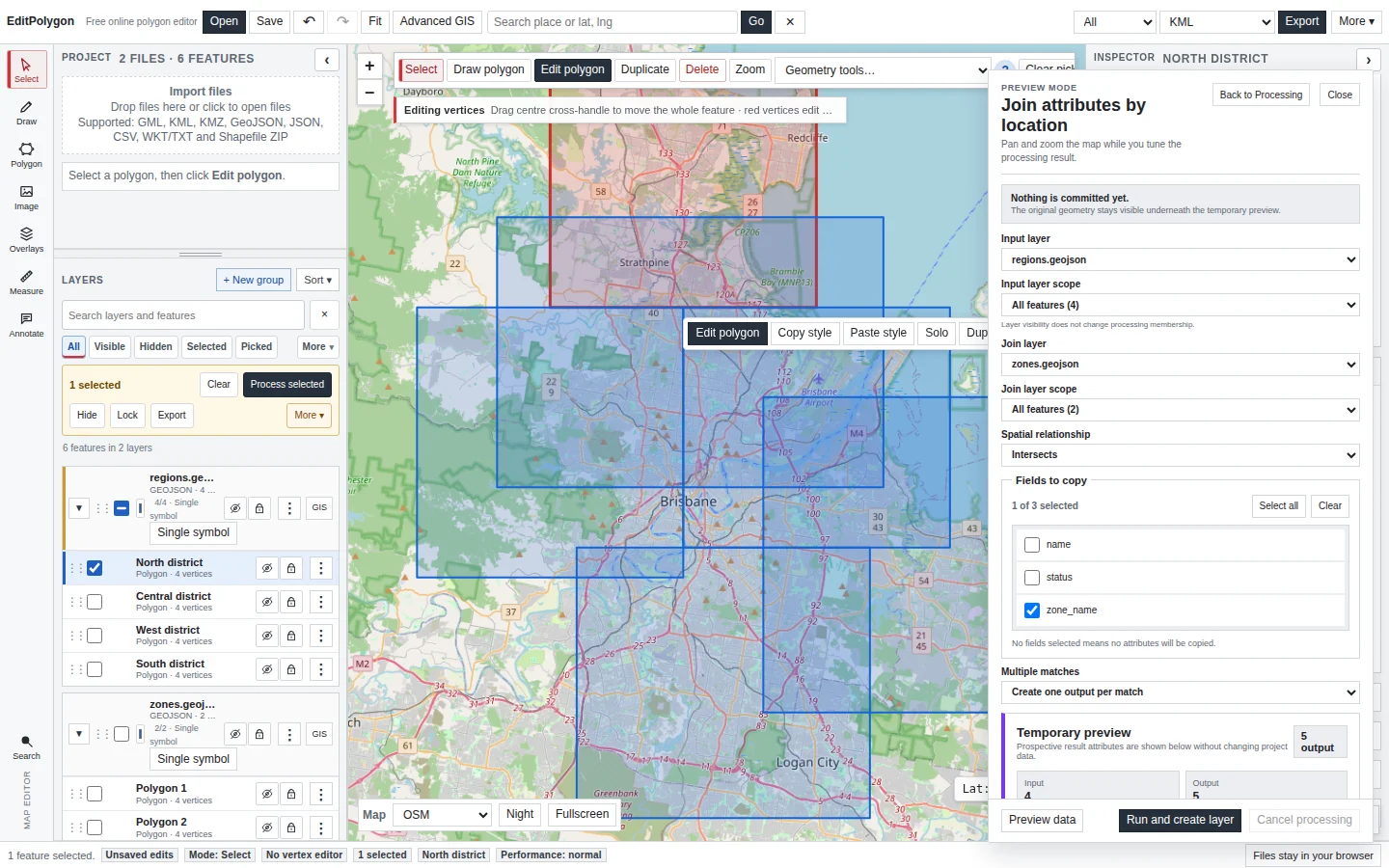
Open Processing → Join attributes by location. The source/input layer keeps its geometry; the join layer supplies spatial matches and the fields you choose to copy.
- Choose the Input layer and scope.
This is the geometry you want in the output.
- Choose the Join layer and scope.
This layer supplies the matching records and copied attributes.
- Choose the Spatial relationship.
Intersects is often right for crossing zones; use Within/Contains only when complete containment is required.
- Select Fields to copy.
Copy only the fields needed downstream rather than duplicating an entire wide schema without reason.
- Choose how multiple matches are handled.
Then use Preview data before committing the output layer.
Handle multiple spatial matches explicitly
One input feature can match several features in the join layer, particularly when reference polygons overlap or when a large input zone intersects many smaller polygons.
Creates one result record for the source feature and takes the first matching join record. Use only when your data model guarantees that one match is appropriate or the ordering is intentionally meaningful.
Duplicates the source geometry once for each spatial match and copies the corresponding join fields to each record. This preserves every relationship.
For a Fire Weather District that intersects 12 LGAs, Create one output per match produces 12 records for that district—each with the same district geometry and a different LGA attribute.
The duplicate shapes represent multiple relational records. If you only want a non-spatial district/LGA lookup table, export the joined attributes as a plain CSV after the join.
Preview the joined data
Join attributes by location uses a data-result preview. Geometry remains normal on the map while a small prospective result table shows the fields that would be added to the output.
Check:
- The number of source records and prospective output records.
- Whether expected fields have non-null joined values.
- Whether expanded matches create the expected repeated source records.
- Whether the relationship is too broad—for example, Intersects may include a polygon that only touches at an edge if that is how the source geometry is constructed.
Export a spatial join as a normal CSV
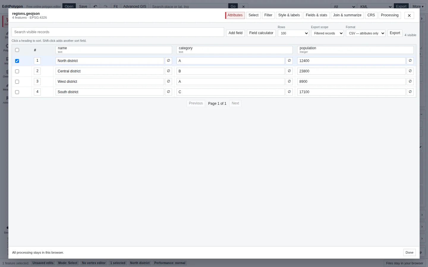
After creating the joined layer, open its Attributes table. When the downstream task is Excel, Power BI or another tabular workflow, choose:
Format → CSV — attributes only
This writes one row per joined result without a WKT geometry column. The separate CSV + WKT option exists for workflows that genuinely need geometry encoded as text.
Select by location when you only need matches
If the goal is “select every feature from Layer A that intersects Layer B,” do not create a joined layer merely to find the matches. Use Select by location.
The selection tool supports the same spatial relationship vocabulary and can Replace, Add, Remove or Intersect the existing selection. Its preview highlights prospective matches without mutating the project selection until applied.
Spatial summary when you need one record per input feature
Use Spatial summary when many matching features should be aggregated into one value on each input feature rather than expanded into one record per match.
The current Processing tool can summarise matching records using Count, Sum, Mean, Minimum or Maximum. Choose a summary field where required and name the output field clearly.
This is the correct pattern for questions such as “how many incidents fall in each district?” or “what is the maximum severity among features intersecting each zone?”
Count points in polygon
Count points in polygon is a purpose-built spatial analysis tool. Choose a polygon input layer and a point overlay layer; the output keeps each polygon and adds the point count. Use it instead of building a generic spatial join when point count is the actual result you need.
When you need overlap area or percentage
Join attributes by location tells you that two features match spatially. It does not calculate how much of one polygon lies inside another.
For a question such as “what percentage of this district is in each LGA?”, use an overlay workflow:
- Run Intersection between the two polygon layers so each overlap becomes real output geometry with attributes from both.
- Calculate or inspect overlap area.
Use area-aware fields/statistics appropriate to the required CRS and units.
- Compare with the source area.
Calculate the percentage in a field or downstream table.
Do not infer percentage from the number of intersecting records; polygon sizes vary.
Check geometry and CRS when spatial results look wrong
Unexpected spatial matches can come from invalid geometry, wrong CRS interpretation or a relationship that does not match the question. Inspect both layers on the map, verify CRS metadata and run Geometry Health when topology is suspect before assuming the spatial engine is wrong.
- The input layer is the geometry you want to retain in the result.
- The chosen spatial relationship matches the actual question.
- Multiple matches are either deliberately reduced to one or expanded to one output per match.
- Preview data has plausible record counts and joined values.
- Spatial summary is used instead of an expanded join when one aggregated result per source feature is required.
- Attribute-only CSV is used when the downstream product is a lookup table rather than spatial geometry.
Common questions
What is the difference between Select by location and a spatial join?
Select by location changes the selection state based on a spatial relationship. A spatial join creates or copies attribute relationships into an output dataset.
When should I use a spatial summary?
Use a spatial summary when you need aggregated values or counts from related features rather than one output record for every individual spatial match.