Choose the right local-file workflow and keep multipart formats packaged correctly.
Choose the correct local-file workflow
EditPolygon's local importer reads supported datasets entirely in the browser. The important distinction is whether the GIS format is a single file or a collection of files that must stay packaged together.
Data and metadata retained on import
EditPolygon retains ordinary feature attributes and attempts to capture compatible source identifiers, descriptions, styling and origin information when available. Some import routes intentionally do not preserve everything: the fast large-KML/KMZ reader captures a bounded set of simple values rather than the entire XML document; optimized imports may simplify geometry; and GeoPackage/File Geodatabase conversion does not reproduce database relationships, domains or all package metadata. Large source documents are subject to an inspection-size limit. The Export dialog only offers data actually retained in the project.
| Format | Open it as | Result | Notes |
|---|---|---|---|
| GeoJSON / JSON | Direct file | Editable vector | GeoJSON Features and FeatureCollections. |
| KML / KMZ | Direct file | Editable vector | KMZ stays packaged; presentation constructs may not round-trip exactly. |
| GML | Direct file | Editable vector | Includes supported curved geometry such as CircleByCenterPoint. |
| GeoPackage (.gpkg) | Direct file | Editable vector | Feature tables are read locally in the browser. |
| GeoPackage ZIP | Keep ZIPped | Editable vector | The importer discovers a nested .gpkg automatically. |
| Shapefile | Keep .shp/.dbf/.shx/.prj together in one ZIP | Editable vector | Do not open extracted component files one at a time. |
| Esri File Geodatabase | Keep the .gdb directory inside a ZIP | Editable vector | A FileGDB is a directory dataset, not an individual .gdbtable file. |
| TopoJSON | Direct file | Editable vector | Imported topology is converted to editable feature geometry. |
| CSV | Direct file | Table / geometry where supported | Coordinate/WKT columns determine whether spatial geometry can be created. |
| WKT / TXT | Direct file | Editable vector | Well-Known Text geometry. |
| EditPolygon .epz | Direct file | Complete project | Restores project-specific layers and editor state. |
A Shapefile is a coordinated set of files. An Esri File Geodatabase is a directory dataset. Keep the complete dataset together so the importer can interpret it correctly.
What each import route can retain
| Source format | Available after normal import | Not guaranteed |
|---|---|---|
| GeoJSON | Common feature properties, original IDs and supported small collection metadata. | Arbitrary foreign-member structures and unusual styling extensions. |
| KML / KMZ | Placemark names, common ExtendedData, safe descriptions and simple source styling/folders. | Complete original XML, StyleMaps, tours, altitude semantics and packaged resources. |
| Large KML / KMZ | Geometry and bounded simple ExtendedData and inline styles where detected by the fast reader. | Full source XML and resources; optional full-source inspection has an 8 MB limit. |
| GML | Supported geometry, simple attributes and available feature IDs. | Complete application schemas, nested attributes and original namespaces. |
| Shapefile ZIP | Geometry, parsed DBF fields and available CRS metadata. | Exact original DBF schema, encoding nuances and unrelated package documents. |
| GeoPackage / FileGDB | Supported feature tables, geometry, parsed attributes and relevant source-table identity. | Full database relationships, field domains, attachments and auxiliary metadata. |
| Coordinate CSV / WKT | Supported geometry and mapped CSV columns. | Unsupported layouts and metadata not expressed by the input file. |
TopoJSON is materialised into editable features, not retained in its original topology encoding. Optimised ArcGIS imports may keep returned attributes while generalising geometry; see remote-data limitations.
Check the Attributes table and source geometry detail. The export selector only offers categories actually retained in the project and compatible with the chosen output format. Keep your authoritative original, plus an .epz checkpoint for continuing work.
Open files from the editor
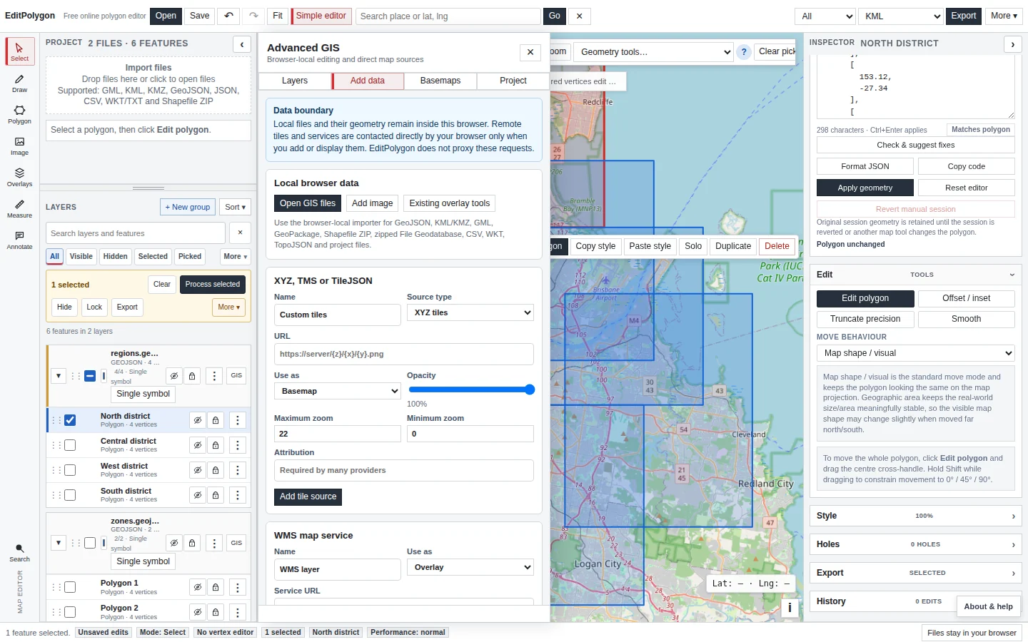
You can start local import in three equivalent places:
- Open in the top toolbar.
- The Project drop area in the simple workspace.
- Advanced GIS → Add data → Open GIS files.
After import, confirm the layer name, feature count and map position. If a file contains multiple feature classes or tables, the imported result may represent those source layers separately or preserve source-layer information where needed.
GeoPackage
A GeoPackage is a SQLite-based container and normally has a .gpkg extension. Open the .gpkg directly. EditPolygon reads supported feature tables locally and converts their geometry into the editor's canonical editable model.
If a provider gives you a ZIP that contains a GeoPackage, you can also open the ZIP directly. The importer inspects the archive, finds the nested .gpkg, and sends it through the GeoPackage parser instead of incorrectly treating every ZIP as a Shapefile.
Successful import does not mean every source CRS decision is correct. After opening projected or unusual data, inspect the layer's CRS information before making coordinate-sensitive changes.
Shapefile ZIP
Keep the Shapefile components in one ZIP. A normal package contains at least .shp, .dbf and .shx; a .prj is strongly preferable because it describes the source coordinate reference system.
Do not expect an extracted .shp alone to contain the complete dataset. The geometry, attributes and index are distributed across the companion files.
Esri File Geodatabase ZIP
A File Geodatabase is a directory ending in .gdb and containing many internal files such as .gdbtable and .gdbtablx. Those internal files are not useful individually.
- Keep the complete
.gdbdirectory.Do not select one internal table file.
- ZIP the directory if it is not already packaged.
The archive can contain parent folders; EditPolygon discovers the nested
.gdb. - Open the ZIP.
The importer recognises the FileGDB structure and routes it through the File Geodatabase parser.
- Inspect the imported feature classes.
Confirm geometry types, attributes and CRS before editing.
KML, KMZ and GML
KML and GML can be opened directly. KMZ should remain as the original .kmz archive; EditPolygon decompresses supported KML content in the browser.
EditPolygon concentrates on editable spatial geometry and common attributes. Complex KML presentation constructs—such as tours, models, NetworkLinks, specialised styles and embedded resources—may require separate verification after export.
GML can preserve supported curved geometry such as CircleByCenterPoint. See Draw and edit true GML circles before converting a true circle to a polygon-only format or operation.
GeoJSON, JSON and TopoJSON
GeoJSON Features and FeatureCollections are imported as normal editable vector data. Geometry code remains available later for direct inspection or replacement of individual Point, LineString, Polygon and multipart geometries.
TopoJSON is accepted as an interchange source and is converted into editable feature geometry. Once imported, normal project editing operates on the resulting feature model rather than the original topology encoding.
Import projected coordinate CSV safely
CSV exports made in a projected CRS include easting, northing and coordinate_crs fields such as EPSG:7856. EditPolygon recognises this combination and transforms the coordinates to internal WGS 84 before drawing them. Latitude/longitude CSV continues to work without projected-CRS metadata. For an external projected CSV, supply an explicit supported coordinate_crs column; the importer rejects ambiguous projected easting/northing columns instead of guessing their datum or zone.
Source CRS metadata is retained independently of map storage. Mixed CRS values within one CSV are rejected; split the source into separate coordinate systems before import. Official datum grid corrections are not installed, so GDA94/GDA2020 cross-datum transformations remain approximate.
CSV and WKT
CSV can represent a normal attribute table or spatial records when the source includes geometry-bearing columns that EditPolygon can interpret. WKT/TXT can be used for Well-Known Text geometry.
If your goal is to get tabular data out of EditPolygon rather than import it, the Attributes table now provides CSV — attributes only. That is different from CSV + WKT, which deliberately includes geometry as text.
Understand import errors
A ZIP says that it contains no supported spatial dataset
The archive does not look like a supported Shapefile, nested GeoPackage or zipped File Geodatabase. Check what the provider actually exported and confirm the complete dataset is inside the ZIP.
A file is reported as Microsoft Intune encrypted
The bytes are an organisational MAM/Intune wrapper rather than the original GIS file. Export or obtain an unencrypted copy through an approved organisational workflow; renaming the file does not decrypt it.
The data imports but is nowhere near the expected location
Use Fit first. If the layer is still misplaced, inspect the CRS. Projected coordinates interpreted as longitude/latitude require the CRS interpretation workflow rather than manual geometry repair.
A KMZ imports geometry but looks different from the source application
Separate geometry from presentation. KML/KMZ styling, folders, icons and application-specific constructs may not be reproduced exactly even when the vector boundary is correct.
Browser-local data boundary
Local files are decoded and processed in the browser. Adding a remote service is different: the browser contacts that provider directly when you discover, import or display the source. EditPolygon does not need to upload your local file to a geoprocessing server to open it.
See Add remote GIS data and services for the web-source workflow.
- The correct file or complete dataset package was opened.
- Shapefile and FileGDB components were kept together.
- The imported feature count is plausible.
- The layer appears in the expected real-world location.
- CRS information was reviewed when the source is projected or ambiguous.
- The original source package was retained unchanged.