Processing uses one tool definition and one engine path for Preview and Run.
Processing is the repeatable GIS operation model
The Processing Toolbox is the authoritative place for layer-wide vector analysis and geometry operations. A Processing request names the tool, input layer(s), explicit scope, parameters and output behaviour. Preview and Run use the same underlying Processing operation rather than separate simplified implementations.
Open the Data/GIS window and choose Processing. The catalogue is organised into Vector geometry, Overlay, Aggregation, Geometry conversion, Selection, Spatial analysis and Geometry maintenance.
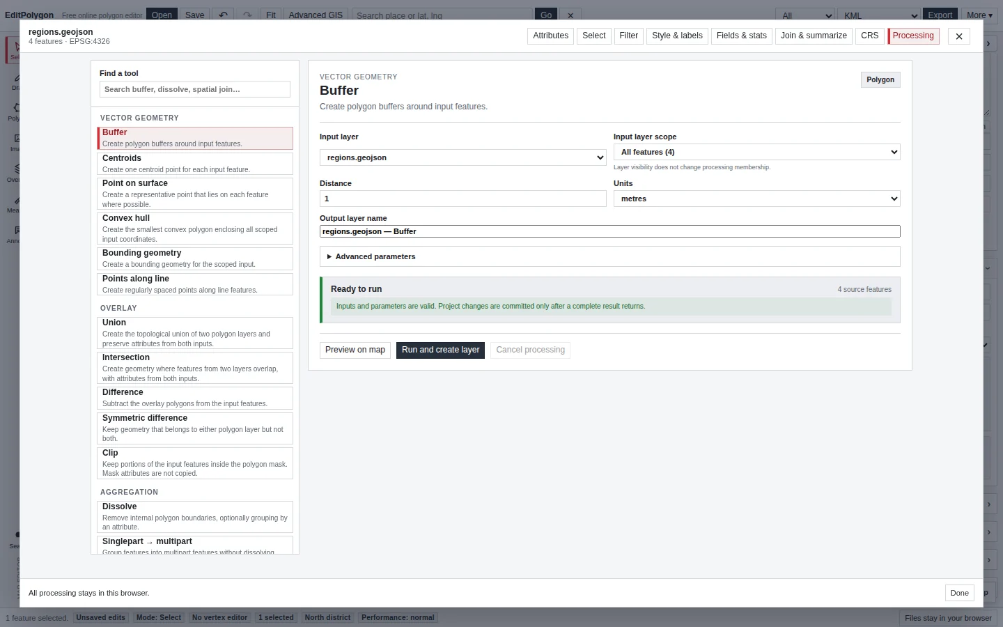
Choose input layers and scopes deliberately
Where supported, each vector input can use:
- All — every eligible feature in the chosen layer.
- Filtered — records that currently pass that layer's filter.
- Selected — feature IDs currently selected in that layer.
Visibility does not change Processing membership. A hidden feature can still be part of All scope, which prevents a map-presentation choice from silently changing an analysis result.
For two-layer operations, source and overlay/reference inputs have independent layer and scope controls.
While Dissolve is open, selecting polygons updates its working scope immediately. If the selected polygons are all in one editable layer, that layer switches to Selected scope. If the selection spans multiple editable layers, EditPolygon presents one temporary Live selection input containing those selected polygons so they can be dissolved together without first merging the layers.
Read the preflight before running
The Processing form validates geometry compatibility, required parameters, schema-dependent choices and input counts before execution. It also explains important execution behaviour such as projected-metric processing when a topology or distance operation needs an appropriate local CRS.
If the preflight count is not what you expect, stop and check the layer, filter, selection and scope before running the algorithm.
Use the right preview mode
Preview is temporary and non-destructive. It does not create a layer, enter project history, appear in export, persist in .epz, or become editable/selectable project geometry.
Draws prospective output over the unchanged source geometry so you can compare boundaries and shapes on the map.
Highlights prospective selection matches without changing the canonical project selection.
Shows prospective result attributes for spatial analysis tools while leaving source geometry and attributes unchanged.
If a tool or context cannot provide a useful preview, rely on the validated form and an output layer that preserves the source.
Work in map-first Preview Mode
Choose Preview on map for a geometry-producing tool. The full Processing window changes to a compact floating Preview Mode controller so the map remains available for pan and zoom while you tune the operation.
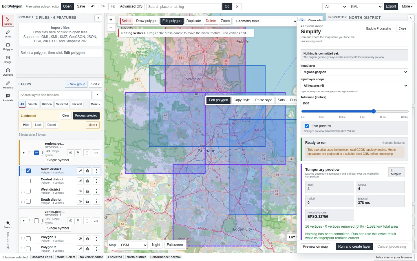
The Preview Mode controls have distinct jobs:
- Back to Processing returns to the complete Toolbox form and preserves the current preview.
- Close clears the preview, exits Processing and returns to the normal map.
- Cancel preview appears while a preview calculation is running and aborts that calculation.
- Cancel processing aborts the authoritative Run while it is active.
Pan and zoom do not intentionally clear the preview. The overlay is temporary, but it is part of the current Preview Mode until you invalidate or close it.
Understand live preview and Refresh preview
Live preview is reserved for operations and scope sizes where recomputing after a parameter change is reasonable. Simplify and Densify use exact numeric input plus a logarithmic-style metre slider; after you activate Preview once, eligible parameter changes can refresh after a short debounce.
Expensive or large jobs do not continuously run on every keystroke. When their parameters change, the existing preview becomes stale and the action becomes Refresh preview.
EditPolygon can calculate a complete Processing result while limiting temporary map rendering to a manageable number of preview features. The preview summary tells you when not every calculated feature is being drawn.
Use preview metrics as diagnostics
Tool-specific metrics help you understand the operation rather than judging only by appearance.
- Simplify reports before/after vertex counts, vertices removed and percentage reduction.
- Densify reports vertices added and longest-segment changes.
- Snap reports inserted/removed vertices separately from moved existing vertices and reports maximum displacement for aligned vertices.
Metrics are diagnostic, not a substitute for map inspection. A large vertex reduction may be technically valid but still remove a boundary detail that matters operationally.
Run and commit the result
Most Processing tools create a new layer. Geometry maintenance tools that advertise new or modify source can instead update the input layer. Source modification is committed as one normal undoable project operation.
When a successful preview is still current—same tool, scoped source data, parameters, schemas, selection context and Processing CRS—Run can commit the already calculated prepared result through the normal authoritative commit path. In that case, what you previewed is literally the result being committed. If the fingerprint is stale, Processing calculates again.
Running from Preview Mode keeps you on the map and displays the completion result there rather than forcing you back into the full Toolbox.
Know what invalidates a preview
A temporary preview becomes stale when algorithm-relevant state changes, including the tool, source/overlay layer, scope, parameters, source geometry or relevant selection. Old preview jobs are cancelled or ignored so a slower obsolete result cannot overwrite a newer request.
Changing an output layer name alone does not change the algorithm result and therefore does not need to invalidate otherwise identical computed geometry.
Metric and topology operations
Processing stores project geometry canonically but can project a request to a suitable metric CRS when GEOS topology or real-world distances require it. The result is transformed back to project storage after processing.
The Processing summary reports the Processing CRS where relevant. See Assign and reproject a CRS if the source layer itself is being interpreted in the wrong coordinate system.
Current Processing tool reference
This table is generated directly from the current Processing registry when the guides are built. It is not a separately maintained list.
| Tool | Available input scopes | Preview | Result |
|---|---|---|---|
| Vector geometry | |||
| Buffer Create polygon buffers around input features. | All / Filtered / Selected | Map preview | New layer |
| Centroids Create one centroid point for each input feature. | All / Filtered / Selected | Map preview | New layer |
| Point on surface Create a representative point that lies on each feature where possible. | All / Filtered / Selected | Map preview | New layer |
| Convex hull Create the smallest convex polygon enclosing all scoped input coordinates. | All / Filtered / Selected | Map preview | New layer |
| Bounding geometry Create a bounding geometry for the scoped input. | All / Filtered / Selected | Map preview | New layer |
| Points along line Create regularly spaced points along line features. | All / Filtered / Selected | Map preview | New layer |
| Overlay | |||
| Union Create the topological union of two polygon layers and preserve attributes from both inputs. | All / Filtered / Selected; All / Filtered / Selected | Map preview | New layer |
| Intersection Create geometry where features from two layers overlap, with attributes from both inputs. | All / Filtered / Selected; All / Filtered / Selected | Map preview | New layer |
| Difference Subtract the overlay polygons from the input features. | All / Filtered / Selected; All / Filtered / Selected | Map preview | New layer |
| Symmetric difference Keep geometry that belongs to either polygon layer but not both. | All / Filtered / Selected; All / Filtered / Selected | Map preview | New layer |
| Clip Keep portions of the input features inside the polygon mask. Mask attributes are not copied. | All / Filtered / Selected; All / Filtered / Selected | Map preview | New layer |
| Aggregation | |||
| Dissolve Remove internal polygon boundaries, optionally grouping by an attribute. | All / Filtered / Selected | Map preview | New layer |
| Singlepart → multipart Group features into multipart features without dissolving boundaries. | All / Filtered / Selected | Map preview | New layer |
| Geometry conversion | |||
| Multipart → singlepart Split multipart geometry into individual features while copying attributes. | All / Filtered / Selected | Map preview | New layer |
| Polygon → line Convert polygon boundaries and holes to line geometry. | All / Filtered / Selected | Map preview | New layer |
| Line → points Create a point feature for every line vertex. | All / Filtered / Selected | Map preview | New layer |
| Selection | |||
| Select by attribute Select features whose attribute values match a typed condition. | All / Filtered | Selection preview | Selection |
| Select by location Select input features using their spatial relationship to another layer. | All / Filtered; All / Filtered / Selected | Selection preview | Selection |
| Invert selection Invert the current selection inside the chosen input scope. | All / Filtered | Selection preview | Selection |
| Select duplicates Select every feature that belongs to an exact duplicate-geometry group. | All / Filtered | Selection preview | Selection |
| Select invalid geometry Select features with structural or robust topology problems. | All / Filtered | Selection preview | Selection |
| Spatial analysis | |||
| Nearest feature Attach the nearest feature ID and selected attributes from another layer. | All / Filtered / Selected; All / Filtered / Selected | Data preview | New layer |
| Distance to nearest Calculate the metric distance from each input feature to its nearest feature in another layer. | All / Filtered / Selected; All / Filtered / Selected | Data preview | New layer |
| Count points in polygon Count points from another layer inside each polygon. | All / Filtered / Selected; All / Filtered / Selected | Data preview | New layer |
| Join attributes by location Copy attributes from spatially matching features into the input layer. | All / Filtered / Selected; All / Filtered / Selected | Data preview | New layer |
| Spatial summary Summarise matching features onto each input feature. | All / Filtered / Selected; All / Filtered / Selected | Data preview | New layer |
| Geometry maintenance | |||
| Fix geometries Apply safe Geometry Health cleanup and robust MakeValid where required. | All / Filtered / Selected | Map preview | New layer or modify source |
| Remove duplicate vertices Remove consecutive duplicate coordinates without changing feature meaning. | All / Filtered / Selected | Map preview | New layer or modify source |
| Remove duplicate features Keep the first feature from each exact duplicate-geometry group. | All / Filtered / Selected | Map preview | New layer or modify source |
| Snap Snap input geometry to nearby geometry in a reference layer. | All / Filtered / Selected; All / Filtered / Selected | Map preview | New layer or modify source |
| Simplify Reduce vertex count while preserving topology. | All / Filtered / Selected | Map preview · live after first preview | New layer or modify source |
| Densify Insert vertices so no segment exceeds the requested metric length. | All / Filtered / Selected | Map preview · live after first preview | New layer or modify source |
Common tool distinctions
Dissolve or Union?
Dissolve aggregates polygon features from one input layer and removes internal boundaries, optionally grouping by a field. Union is a two-layer overlay that partitions the combined area and preserves attributes from both inputs.
Clip or Intersection?
Clip keeps the parts of the input inside a polygon mask and does not copy mask attributes. Intersection creates overlapping geometry and combines attributes from both inputs.
Select by location or Join attributes by location?
Use selection when you only need to mark matching input features. Use Join attributes by location when you need fields from matching features copied into an output dataset.
Fix geometries or Geometry Health?
Geometry Health is the review-oriented validation workflow. Processing → Fix geometries is the repeatable maintenance operation for applying safe cleanup/MakeValid across an explicit layer scope.
- The correct tool and compatible input layer(s) are selected.
- All, Filtered or Selected scope matches the intended membership.
- Preflight counts are plausible.
- A preview was reviewed when the operation can materially change geometry or data.
- Stale previews were refreshed after relevant changes.
- New-layer versus modify-source output behaviour is intentional.
- The committed result was inspected before the source or project was discarded.